
Papers

Reports and analyses from around the world are presented at MW2005.
| Workshops |
| Sessions |
| Speakers |
| Interactions |
| Demonstrations |
| Exhibits |
| Best of the Web |
| produced by
|
| Search A&MI
|
| Join our Mailing List Privacy Policy |
Place-based Storytelling Tools: A new look at Monticello
Brad Johnson, Second Story Interactive Studios, USA
Abstract
Many cultural institutions face the challenges of making their collections accessible and interpreting them on-line. But what if the 'collection' isn't something on a wall, in a case, or in storage, but is a house, a ship, a 5,000-acre plantation, or all the tombs in the Valley of the Kings? This is an in-depth look at how museums can create rich, immersive interactive sites that connect on-line audiences with places and spaces,- and the ideas, people, objects and histories that have inhabited them. This genre of museum site provides accessibility to physically restrictive locations including remote locales, endangered sites, restricted or dangerous areas, inaccessible rooms, and places that no longer exist. Since most house museums were built before ADA guidelines, these Web sites create new opportunities for disabled visitors to explore places they have never been. Experiences can go beyond the physical limitations of real geographies and beyond the chronological constraints of the present, revealing how a place evolved over time.
Building on the lessons learned from the Theban Mapping Project, Yin Yu Tang, and the new interactive Monticello Explorer site, Second Story and the Thomas Jefferson Foundation examine the genesis, process and result of their exciting new database-driven 3D experience that brings Jefferson, his house and plantation to life on-line.
Keywords: physically restrictive locations, endangered sites, disabled visitors
Introduction
"Jefferson's real autobiography is Monticello. You can walk around the house and you begin to see the man." (David McCullough, 1997)

Fig 1: Monticello, the home of Thomas Jefferson
Few can leave a visit to the home of Thomas Jefferson unaffected. From the plantation setting to the approach up the mountaintop and the first glimpse of the house, through each stop in the tour, Monticello reveals itself as the inspiring self-portrait of a heroic Renaissance man. As visitors pass through each room, Jefferson's architectural vision gives structure to his ceaseless curiosities and diverse accomplishments, and the artifacts and stories encountered in each location all make Jefferson, his ideas and his world come to life.
Developing a compelling electronic experience that elicits similar reactions from on-line audiences is a daunting task. While it is impossible to recreate the feeling of being there, well-conceived orchestration of multimedia's most engaging ingredients - comprehensive databases, compelling 3D visualizations, intelligent mapping, rich audio/video, intuitive user interfaces and great content - can transport viewers' imaginations to places they have never been.
Fixed Presentation or Dynamic Tool
One of the first considerations in determining how to realize a place-based Web site is to determine how dynamic the offering needs to be. If the subject of the site is a location where active research or ongoing reinterpretation is happening, or where collections are growing or changing, a fixed or canned presentation would become inadequate over time, or require considerable maintenance to update. Conversely, a database-driven dynamic solution might be a waste of effort and money if the content never needs to change. To illustrate the differences and appropriateness of each of these approaches, the fixed Yin Yu Tan' site at the Peabody Essex Museum will be contrasted with the dynamic Atlas of the Valley of the Kings for the Theban Mapping Project.
Yu Tang is an elegant, rural home originally located in a small, remote village in the southeastern region of Huizhou in China's Anhui Province. Built in the late Qing dynasty (1644-1911) by a Chinese merchant surnamed Huang, the residence was home to the Huang family for over two hundred years. By the mid-nineteen-eighties, all surviving Huang family members had moved away from their home which sat in silence until 1997, when the family and the government authorized that the house be transported across the world, to be opened to the public at the Peabody Essex Museum in Salem, Massachusetts. The museum commissioned a Web site for visitors to explore the house to discover this rare example of the region's renowned architecture and learn about the daily life of the Huang family.
Once the house was re-erected in the museum and filled with objects and belongings, active research, interpretation and collecting came to a close. There was no need for a Yin Yu Tang collection database or for content management tools to make ongoing additions or edits to the site. It was important that the museum direct how the materials in the Web site be presented, and clear that providing unmediated access to house features or collection records would not support the interpretive goals of the museum. For these reasons, a canned or fixed presentation was more appropriate and more affordable.
By contrast, the needs of the Theban Mapping project were very different. Since 1978, the Theban Mapping Project, under the direction of Egyptologist Dr. Kent Weeks, has been working to prepare a comprehensive archaeological database of the Valley and the entire Theban Necropolis. With information about every archaeological, geological and ethnographic feature in the Valley of the Kings, nearly 6,000 photographs and illustrations, over 250 detailed maps, elevations and sections, exhaustive bibliographic resources, articles and glossaries - and a full-time staff engaged in ongoing research, archeological digs, surveying and photography - this organization needed a Web site that could easily be updated, added to and modified. Beyond the needs of a dynamic Web-based publishing system to accommodate active research and interpretation, what are other factors to consider in determining whether a place-based Web site should be fixed or database-driven?
Is the institution providing a resource for self-directed research, or is the site an on-line equivalent of a house tour? Database-driven solutions are needed when visitors can search for items within a place or when they can access records for items in customized inquiries outside a mediated tour track. For example, when particular objects, ideas or people can be related to multiple locations within a place, or when there are enough meaningful relationships defined between these records that a visitor could discover things based on personalized inquiries, a database solution is imperative. Without the ongoing need to easily publish new records or new interpretive content, without the need to facilitate personalized search and discovery for visitors, and without an existing database, a dynamic, database-driven solution is unnecessary. At Monticello, an existing collection database, a staff devoted to ongoing interpretation, a team of archeologists conducting ongoing research, the need for powerful searches and the need to make the Web site a tool for self-directed inquiry as well as for virtual tours - all required a dynamic solution.
The idea of connecting locations with a database is straightforward: records in a collection have a relationship with locations (and vice versa). Visitors discover records related to a place as they move from one location to another, or they discover locations related to records as they navigate through a database. The job of a place-based storytelling tool is to spatially contextualize content related to the place so that the relationship between records and locations is clearly established. This context requires compelling representations of locations that clearly describe and interconnect places, so visitors can intuit the relationships between the locations.
3D Representations of a Place
Monticello refers not only to the house that Thomas Jefferson built, but to the entire mountaintop and plantation as well. The task was to make a site that contextualized content with locations that were both architectural and purely geographic (outside). Some locations were rooms within a house, and other locations were coordinates in a field. While two-dimensional representations of the outdoor locations (maps) were acceptable, two-dimensional representations of the house (measured drawings) would be underwhelming: the third dimension was required to communicate the interiors more intuitively.
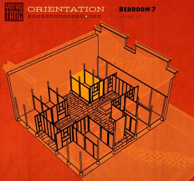
Fig 2: Yin Yu Tang 3D Treatment: 'wireframe hidden-line removed.'
In Yin Yu Tang, the house was primarily represented as a dissected axonometric object. As content was presented, corresponding views of the house were revealed and highlighted. This fixed, persistent orientation in the interface gave visitors an easy contextual architectural reference, but the detached omnipresent perspective lacks an immersive quality. In this Web site, 3D was employed exclusively for visualization: visitors could not navigate from one location to another within the 3D model.

Fig 3: Theban Mapping Project Description Mode Treatment: when navigating through the tombs in the self-directed 'Description' mode, visitors could use the scalable vector (axonometric) wireframe treatments to navigate from chamber to chamber.

Figure 4: Theban Mapping Project 3D Tour Treatments: when the tour guide moves through the spaces and refers to architectural features, the wireframe treatment (above) is a lower bandwidth option that communicates the interior spaces; when the guide refers to the surface decorations on the walls, laser scans are revealed that link to high resolution color images.
In the Theban Mapping Project, tombs were represented in many different ways. The Description section displayed data and images in context as visitors selected different 'rooms' in a reactive wireframe axonometric representation. A non-navigable 3D tour of one of the tombs (visitors could pause, play and jump to cue points in the linear narrative) was treated with the architectural 'wireframe hidden-line removed' style with QuantaPoint scans interspersed. This fast loading approach was made possible by the Swift3D renderer that exports Flash vector graphics and proved to be extremely accurate and appropriate for interpreting the architectural spaces. More bandwidth was used for the grayscale bitmaps that revealed the surface decoration on the tomb's walls.

Fig 5: 'Unwrapped: The Mysterious World of Mummies' treatment employed a 3D game style with texture maps and dramatic lighting.
In Unwrapped: the Mysterious World of Mummies, a generic tomb from the Valley of the Kings was recreated in convincing 3D, complete with texture maps and dramatic lighting. This inaccurate 'caricature' was acceptable for the intended game-like experience of this TLC (Discovery Communications) site. Here the 3D is more than a visual aid: within the 3D experience visitors can navigate from one predefined node to another and can pivot and look in any direction. In certain sections, they can roll over features in the tomb and access more specif ic interpretive information.
In Monticello we were determined to combine the best of these approaches where the model served as a visualization tool and a navigation device: visitors would be immersed inside the virtual spaces of the model and use it to navigate from room to room.
Realistic 3D models of an architectural space require comprehensive, accurate measurements which can be obtained in at least two ways. Measured drawings, (plans, sections, elevations) derived from human observation have been until recently the only means by which measurements could be made. Digital measured drawings of Yin Yu Tang were developed by preservation architects in CAD format that modelers could use as a reference in 3D programs. The measured drawings of Monticello came from the Historic American Building Survey (HABS), but unfortunately they were literal drawings created before CAD was prevalent. While the data is still there, the amount of work required to input all these values was immense. Fortunately, a laser scanning technique used in the tombs in the Valley of the Kings for the Theban Mapping Project was also an option at Monticello.

Fig 6: Historic American Building Survey (HABS) plan showing the South Square room in Monticello.
Laser scanners developed by QuantaPoint were employed to scan the interior and exterior of the house on two occasions. A small portable scanning unit is strategically positioned throughout the house. At each position the unit's head spins and tilts, emitting a laser beam that records the distance from itself to every surface surrounding it in every direction. The resulting point cloud represents the observable surfaces in the room and can in turn be converted into 3D modeling data.

Fig 7: Point cloud generated from laser scan of the South Square room.
Unlike the drawings obtained by human observation, this technology records every imperfection, anomaly or characteristic that often occurs in old buildings over time, but remains virtually undetectable by human observation. In addition to the greater accuracy of data, the time required to capture that data with a laser scanner is a fraction of the alternative.

Fig 8: Studies of various rendering techniques were created to evaluate appropriate ways to represent the house in 3D.
The model of the house could now be created, and after considering many different rendering techniques, two distinct treatments were chosen: as visitors move from room to room or pivot within one room, a simplified vector wireframe style is used, and when visitors pause, a shaded, lit grayscale bitmap image loads. In this way a fast loading vector solution gives visitors a sense of the spaces and the relationships between them as they navigate, and the shaded grayscale communicates Jefferson's original architectural vision of the house.

Fig 9: This vector wireframe treatment of the South Square room was rendered with the Swift3D plug-in for 3D Studio Max: a tool for creating 3D graphics in Flash.

Fig 10: This shaded grayscale treatment of the South Square room accurately describes the architectural details as well as the play of light throughout the space.
Modes of Navigation
Developing a compelling navigation scheme for the Web site started with an assessment of the way people visit the brick-and-mortar Monticello. There are first time visitors who begin their experience with a general house tour, returning visitors on special thematic tours, visitors exploring the gardens and grounds by themselves, and scholars conducting research. This site needed to have discreet navigation modes to accommodate each of these different visitor profiles, and had to serve a wide gamut of audiences who come with varying amounts of knowledge about Monticello. A browse or explore mode would allow users to directly access locations and related materials through self-directed pathways that reflect their curiosities, and a more controlled tour mode would provide mediated tracks through the site to help uninitiated visitors discover Monticello.
With one integrated application-like feature strategically modularized to serve different audiences (from school children to general visitors to academics) and different bandwidth capabilities (from narrowband to broadband), the project simultaneously accommodates 'surgical researchers' who want fast access to information and visitors who want to be educated and entertained through an immersive tour leading them through the core components of the site. This approach blends the entertaining qualities of interactive storytelling with access to authoritative data and resources.
The tours imagined for this project were unlike any other, and more closely approximate the kind of interpretive tour one would get at Monticello or in a museum. As opposed to a distinct offering within a site - like a narrated movie, for example - these tours are powerful wrappers around the site. In other words, most on-line tours more closely approximate the orientation theater experience in a museum; they are discreet stand-alone features in the site rather than modes of moving through the site itself. Here the tour is in essence a narrated auto-play mode of navigation that guides visitors through the site in scripted pathways that interpret and introduce content (the same content that is freely accessible in self-directed explore mode).
At launch, visitors can select from either one of two tours: a General House Tour or the Domestic Life at Monticello Tour. Tours are comprised of a series of narrated segments strung together, much as a house tour guide delivers discreet segments at defined nodes in the house. Tours can be experienced in the following ways:
- Tours can be in a passive linear format from beginning to end, just as visitors to the real house might follow their guide through an entire tour.
- Tours can be paused while users digress and investigate records in more detail, just as visitors may wish to stop in the cabinet and study the polygraph while the guide and group wait for them (but can't really do).
- Tours can interconnect, enabling visitors to leave the General House Tour and join the Domestic Life at Monticello Tour (imagine being on a tour in an art museum and overhearing another - more interesting - tour and joining the other group).
- Tours can be abandoned at any point, leaving the visitor at the active location in explore mode (imagine staying in Jefferson's library to explore everything in the room while the group moves on!).
- Tours can be joined midstream such that users exploring the house on their own can join a tour in the current location (imagine wandering around the house, overhearing an interesting guide in the parlor, and joining their tour).
As each of these cases illustrate, tours are another means of navigating the site, and visitors are free to weave in and out of them throughout their experience, navigating between mediated and self-directed exploration modes.
Instead of the tours, visitors can begin their exploration of Monticello by selecting either the plantation or the house. In the plantation section, visitors can select locations by name in a menu list, or pan across and zoom in and out of every detailed feature on a large topographic map of the greater plantation area. Visitors can explore different areas of the mountain, discovering fields, farms, archeological sites, historic roads, gardens or any feature of interest. Selecting the desired historical period controls the visibility of sites, locations and features on the map. In this way, visitors can observe how a place changes over time. In addition to showing changes in the plantation, the exteriors of the current house and Jefferson's first version of the house were modeled and can be compared at any angle.
When locations are selected, thumbnails of related records are displayed so visitors can see photographs of the location as well as database records that have a relationship to the active location. Each image is a link to an object, a drawing, an animation, a story or another media component. Users can set filters to only show thumbnails and content related to specific inquiry modes (show only architectural details, e.g.), further facilitating customization. In the house, visitors explore by name in a menu list by selecting locations on a floor plan or by navigating within the 3D environment. As visitors move through Monticello, the database records connected to each room spill out into the interface like the contents of an overstuffed curiosity cabinet - each record a portal to help visitors better understand the place, the people that lived there and the man who made it, Thomas Jefferson.
In the end, the application-like qualities of the Web site serve diverse audiences and different learning styles, and - unlike fixed presentations - can be experienced in so many ways that repeated visits can be unique every time. Visitors can tour or explore, and their exploration can be focused to specific time periods or themes. One time a visitor might explore the house learning about Jefferson's life at Monticello, while another time the visit could examine the house's architectural features. The scalable granularity even enables some visitors to fly around the plantation and learn where different farms were located, while others might find out what specific plants are found in a particular flower bed. Combining a structure that supports such customization with the fact that the storytellers at the Thomas Jefferson Foundation will continue to add more records, tours and features throughout the plantation, means this place-based storytelling tool will captivate audiences for many years in unexpected ways.
Future Opportunities
The back end programming that makes this experience possible keeps track of visitors' movements through the site, including all the customization they might make in the course of their exploration. This enables visitors to use the browser's back button to revisit their breadcrumb trail, even though the site is developed in Flash. It is rare to be able to do this in sites developed in Flash, especially such customizable ones. Since the site keeps a running history of the locations visited juxtaposed with the corresponding database records revealed in each location, the visitor is able to capture this state and email the record to colleagues, friends or students. This seemingly small detail turns out to pave the way for powerful enhancements that can be made to the site in the future.
If a visitor can share a customized state in the site, enhancements could be made to save a series of states. In other words, visitors would be able to send a link not only to a single location in the site, but to a string of locations that they assembled according to a specific order, with specific customized states (e.g. only displaying architectural features). An additional enhancement would enable these visitors to annotate each location/state, adding their own text to the string of 'bookmarks.' In this way, viewers could use the site as their own storytelling tool, weaving together their own entertaining playlists of favorite places or scholarly interpretive tours of Monticello to share.
References
Mccullough, D. (1997) "Foreword", Thomas Jefferson's Monticello. Ann M. Lucas and Rebecca L. Bowman. (eds) New York: Monacelli Press, 1997.
Monticello Explorer http://www.monticello.org/
Quantapoint http://www.quantapoint.com/
Theban Mapping Project http://www.thebanmappingproject.com/
Yin Yu Tang http://www.pem.org/yinyutang/
Cite as:
Johnson, B., Place-based Storytelling Tools: A new look at Monticello , in J. Trant and D. Bearman (eds.). Museums and the Web 2005: Proceedings, Toronto: Archives & Museum Informatics, published March 31, 2005 at http://www.archimuse.com/mw2005/papers/johnsonB/johnsonB.html
April 2005
analytic scripts updated:
October 2010
Telephone: +1 416 691 2516 | Fax: +1 416 352 6025 | E-mail: