|
|
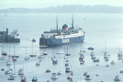
| Fig. 2: St Peter Port Harbour, circa 1980. The ferry is over the wreck site. |
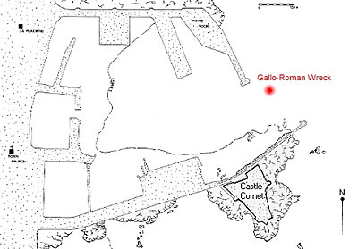
| Fig. 3: Plan of St Peter Port Harbour and the wreck site. |
Subsequently the vessel's antiquity and importance were recognised, as were the circumstances of its exposure. Larger ferries had recently been introduced onto the Channel Island routes and their propeller wash was effectively scouring the seabed as they passed overhead. Further, the local authorities were about to dredge the harbour and its entrance, which would certainly have destroyed the wreck forever. Rapid action was required and a Maritime Trust was formed to generate funding and co-ordinate work on the wreck. By 1985, the wreck (christened 'Asterix' after the cartoon character) had been excavated and the timbers raised, by a team led by Dr Margaret Rule - of Mary Rose Trust fame.
Post excavation work on the finds from the site continued for some time, culminating in a publication issued by Guernsey Museums & Galleries (Rule and Monaghan, 1993).
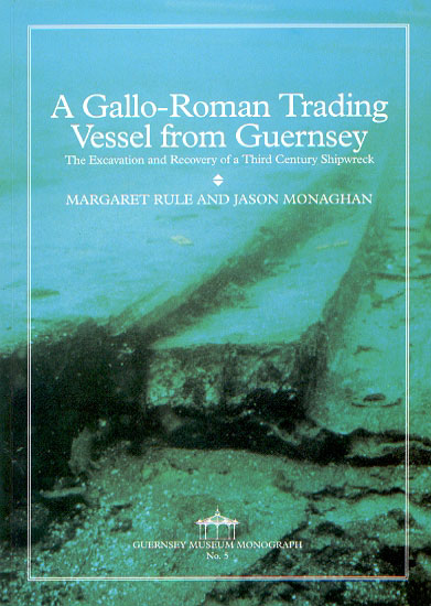
| Fig. 4: Guernsey Museum Monograph 5 offers a detailed description of the wreck |
This established the importance of the wreck in the academic world of ship archaeology and, no doubt, was an important consideration in the reasoning behind the invitation contained in the 1995 letter from Germany. Basically, that letter (addressed to our museum director, as a representative of the Guernsey Maritime Trust) invited us to attend a workshop in Mainz, to discuss the possibility of setting up a consortium of supra-national partners in a project which might attract European Commission (EC) funding. The project would be part of the EC DIRECTORATE GENERAL X or DG XIII initiative, involving the digitisation of cultural property, 'so that the items are accessible by multi media communications systems' and would also seek to establish a 'common European standard of ancient ship documentation.' At the time, Guernsey Museums & Galleries was without an archaeologist, the successor to the previous incumbent having yet to be appointed. Our director was unable to attend but fortunately saw the opportunities which it might offer and asked the writer to attend, as the person primarily responsible for our computer cataloguing and image digitisation initiatives.
The meeting over the weekend of 25-26th November 1995 was hosted by the Museum of Ancient Shipping (Museum für Antike Schiffahrt) in Mainz, Germany. It brought together representatives from 14 institutions in eight European countries, all of which either possessed original ancient wrecks or large inventories of monuments and coins with depictions of ancient ships. The main object of discussion was the establishment of a database of digital images and information relating to ancient European shipwrecks and depictions of ancient ships. Clearly this was a well thought out and timely initiative in a specific academic area which led to a very successful outcome. All the participants agreed to co-operate with the construction of a database, which would be called 'NAVIS'; they further agreed that the cut-off date for included wrecks would be the 12th century. As originally conceived, 'NAVIS' would contain five categories:
- The original ships
- Representations of ships on ancient monuments and coins
- The cargoes of ancient ships
- The conservation of original wrecks
- Data about ship museums
The initial priorities were set as categories 1 and 3, using digitised versions of existing publications, plans and photographs. The concept of Mainz being the central repository for this data was accepted from the start and also the precept that Mainz would undertake the digitisation on behalf of members who were unable to do it for themselves. Access to data was also considered, with the realisation that while much would be freely accessible, some might be confidential and need to be in a password protected part of the database. The concept of a multi-lingual term-list of accepted ship archaeology and ship building terms was accepted from the outset together with the need for appropriate data compilation forms. The meeting also elected Dr Barbara Pferdehirt (Director of the Museum für Antike Schiffahrt) as the co-ordinator of the project.
It had been made clear that little time remained before meetings in Brussels early in December 1995, when proposals for funding under the D G XIII initiative would need to be presented. Dr. Pferdehirt and her staff moved quickly and she reported back to the NAVIS partners early in January 1996, that she (and, on one occasion, one of the Dutch partners) had attended two meetings in Brussels. Things looked favourable for NAVIS as a concept but two overriding criteria would need to be met:
- the resultant data-base must, for the main part be generally accessible to the public, with any private areas password protected
- any institutions (or IT industry collaborators) in receipt of EC funding must be signatories to the European Commission's 'Memorandum of Understanding' document headed 'Humanity 2000: Multi-media Access to the World's Cultural Heritage'.
The public commitment to this document was to be made at a meeting held in conjunction with the Electronic Imaging & the Visual Arts (EVA) Conference in Florence, during February 1996. Would-be signatories without a representative at the meeting (like Guernsey Museum) were to be able to add their names later. Previously, we had also been involved in the gestation of the 'Memorandum', insofar as we received several draft versions of the document for comment, together with invitations to discussion meetings in Brussels. In the event, political commitment to the document was deferred until April 1996 and Guernsey signed the documents a little later.
By March 1996, correspondence from Dr Pferdehirt indicated that the project was awaiting word from Brussels as to which EC programme (DG XIII or DG X) would be appropriate for our funding application. In the meantime, however, the partners had begun work on the terminology control question. A number of sectional drawings of ancient ship sections were circulated, with the parts labelled in German, canvassing appropriate terminology in the eight different languages selected for the database. It must be admitted at this point that the primary discussion language of the formal meetings was English and generally speaking therefore most of the terminology was already available in that language, so this did not involve Guernsey in very much effort. This was fortunate, in view of my own lack of expertise in the area of wooden ship construction!
In June 1996, a 21-page copy of the formal application to the European Commission for NAVIS project funding was sent out from Mainz to the project partners for their approval (Pferdehirt, 1996). It contained no surprises, giving the proposed primary subject matter for the database as '46 ancient ships in 16 museums from 10 European countries'. It comprised a well-argued case for support, on both academic and cultural grounds, with the promise of many potential insights into the development of trade, technology and the movement of early peoples. Further, it listed the 16 museums and three research institutions in 10 European countries, making up the NAVIS 'network'. Given the variation in academic expertise, technical, financial and human resources available to the various organisations, it was agreed that eight of the participating institutions should 'responsibly lead the active realisation of the common database-project.' These eight institutions therefore also became the active partners making the formal application to Brussels for EC funding for the NAVIS project. The document went on to give a short institutional profile of each partner, together with an account of what it could bring to the project.
See Appendix for a list of the NAVIS partners.
The application itself continued with a list of the ships to be included, together with the aspects of data and images that would be recorded. It went on to list the alternative languages to be used: Danish, Dutch, English, French, German, Greek, Italian and Spanish. The application document further described the final form of the database, with a three-part structure envisaged:
- A general information kiosk for the public, with information about the museums and topics of general interest, such as 'Roman War Fleets' and 'Ships of the Vikings'.
- The central part of the database would be the mass of images acquired during the course of the project, available both to the general public and the scientific community via a structured system of technical and historical keywords.
- The other part of the database would consist of work in progress or made available for peer validation and would only be available to participating project partners.
Technical details were also provided: the data would be compiled initially on a PC in Mainz, using Microsoft Access 7 and subsequently made available on the internet via a server at Mainz University.
The document went on to elaborate on the advantages which dissemination of information world-wide could bring and also considered the copyright advantages which accrued (or rather the difficulties which did not arise!) as a result of the partners being in control of digitising their own material. It emphasised the pioneering nature of this co-operative project, suggesting that it would become a model for future work but that it could only happen with the requisite EC funding. There followed a breakdown of the projected costs, amounting to 770,750 ECU, to be provided by the NAVIS partners (mainly for staff time) with a shortfall of 251,583 ECU (on the total projected budget of 1,022,333 ECU) to be the amount requested from the EC. Further details of the projected timetable (it was to be a two year project) together with appendices detailing the work done to date, were also submitted. The calculation of Guernsey's institutional contribution to the overall budget was based on the cost of employing an archaeologist for half a day per week, over the project period.
In November 1996 we received word from Mainz that the EU had approved the project but that the amount of subsidy was still unknown. It was not until the end of January 1997 when we heard from Mainz again, that the EU had approved the budget, under the auspices of DG X, without any cuts. Immediately a workshop was arranged for early March 1997, to be held at the Danish National Museum's Institute of Maritime Archaeology at Roskilde.
The Roskilde workshop was a mixture of round table discussions and demonstrations relevant to the project, together with an opportunity to visit the nearby Viking Ship Museum. The discussions particularly revolved around the apportionment of the financial resources newly bestowed by the European Commission. In our own case, the resources to be made available would allow for the acquisition of a single personal computer and a digital camera.
The other main business at Roskilde revolved around the design of the database itself and the actual mechanics of acquiring the images, specifying sizes and resolutions for large images and thumbnails, file name conventions, and a simple text-file catalogue of the images for each ship. The mechanics of transferring the files to Mainz were also discussed, with Travan TR1 tapes being recommended at the time. In practise, and certainly for the relatively small number of images relating to the Guernsey ship, e-mail attachments later proved to be a more efficient method of transferring small batches of images and text files.
The Roskilde meeting provided an opportunity for the partners to see the demonstration of two other programs, the development of which was also included as part of the NAVIS project brief. Photodraw (not to be confused with the new Microsoft product) is the name given to a technique for automating the production of archaeological find illustrations.
| Fig. 5: Example illustration, produced using the Photodraw method. Note that this is a reworked second generation copy, taken from the draft manual |
The technique uses Adobe Photoshop to process digital images, using a specific set of procedures, to produce an accurate illustration, similar in appearance to traditional artwork. It was originally developed to expedite a single research project, in order to automate the illustration of a large quantity of finds from the Nydam excavation. The wider application of the technique was highly apparent and the brief, as far as the NAVIS project was concerned, was to refine the technique down to a properly documented set of procedures. These would be described and illustrated in a printed guide, which would be freely available to the project partners and also might be produced as a saleable publication. This development was to be undertaken at Roskilde, along with the other software development project, the enhancement of a commercial ship-architecture drawing program called I-Ship, to provide specific advantages for the 3-D visualisation of historic ships. As this is peripheral to the main Internet theme of these proceedings (and perhaps of less general interest than the Photodraw technique) it is merely mentioned here, in passing.
The Roskilde meeting was really an inspirational start to the serious NAVIS work as far as Guernsey was concerned. Shortly after the meeting, we took delivery of the new computer (assigned to our recently appointed Archaeology Officer) and an Olympus digital camera. We already had a scanner, so work began in earnest on scanning the images relating to the wreck, together with the assignment of appropriate keywords. It has to be admitted that Guernsey had a much less onerous task in this respect, with its single, uncomplicated ship and a fully illustrated publication. Some of the partners had many wrecks and were undoubtedly faced with a very large task, involving difficult choices about what to include and what to leave out.
The next workshop meeting of the NAVIS partners was held in Mainz during October 1997. Apart from the (now) almost routine discussions about the selection of keywords, their multi-lingual translation and the translation of help files for the database, each partner was also charged with the production of text for a 'home-page' to provide information about each participating institution. This was not completed for Guernsey until a few days later (although it was mostly written during a long wait at Gatwick Airport on the return journey) and sent back to Mainz as an e-mail attached text file. This was duly returned to us as an HTML file with a NAVIS standard grey background and associated image links. At that point in time Guernsey Museums & Galleries did not have a web site, although I was very keen to develop one and had been experimenting with Microsoft Frontpage for some time. Basically the experience and confidence to progress the matter was proving elusive but, then, the file returned from Mainz provided the kernel of a site in one fell swoop. This was a much-needed catalyst and, by February 1998, the museum had its own (rather basic) web site, hosted by the new local ISP Guernsey.Net, with whom we had established a most cordial relationship.
The next projected meeting of the NAVIS partners was scheduled for early 1998 but, in the light of progress, the event was delayed until the weekend of June 20th. This had the added incentive of better weather in Mainz and the event was a highly focused weekend workshop, editing and finalising the multi-lingual keyword lists and help files. On that particular occasion my presence as the sole native English speaker (but not a ship archaeologist) was put to frequent and often taxing use. This responsibility weighed somewhat heavily at times but the general progress was excellent, everyone having been greatly enthused by the initial demonstration of the NAVIS database by Allard Mees - the archaeologist employed at Mainz to develop the system.
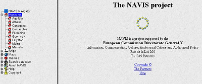
| Fig. 6: Partial screenshot of the NAVIS 1 development web site. |
An example of his work can be seen at http://archweb.leidenuniv.nl/anadecom/myhome.htm where his Roman Ceramics site (on behalf of the Römisch-Germanisches Zentralmuseum) is worth a look for anyone remotely interested in this field and provides a ready made testament to his abilities with this type of data.
There was also positive news about the political desire of officials at the French Ministry of Culture for the inclusion of French shipwrecks in the database, following a private demonstration of the NAVIS database in Paris, by the project director and Allard Mees. French maritime archaeologists had been represented at the initial Mainz meeting in 1997 but had not subsequently participated. This had been attributed mainly to lack of political (and hence financial) support from their individual institutions but there was now increased optimism that central resources would be found in order to ensure the inclusion of the French wrecks.
At the time of writing (January 23, 1999) the final 2 day workshop meeting of the NAVIS partners (within the context of the present EC funded project) is one week away. The agenda consists of finalisation of keyword lists, help files and ship documentation, together with consideration of the publication of the database and its future. The preparation of this paper somewhat in advance of the MW'99 conference, provides a rather appropriate demonstration of the immediacy and flexible nature of web publishing. The database may be on-line by the time of the conference, or it may still be accessible only to the project partners by arrangement. No doubt the existing information site at http://www.rhein-zeitung.de/~rzentral will provide the answer in the meantime and also the relevant new URL in the future.
In conclusion, I would like to reflect on the significance of this project for Guernsey Museums & Galleries. Firstly, contact with NAVIS coincided with our own early attempts at familiarisation with HTML and the Internet. Provision of the 'Guernsey Museum Homepage' for NAVIS gave us the confidence to take this further and develop our own web site. The actual mechanics of NAVIS might well be transferable to the wider context of getting our own collections data on line and this is an avenue that we hope to explore in the future. The experience of working in a multi-national partnership with others has been highly rewarding, both on a personal and professional level. It has also been (and will continue to be) beneficial in raising the profile of Guernsey, its heritage and its museum service. In the context of our own particular wreck (which has been awaiting the start of conservation for the last 15 years) it will also hopefully help to convince the funding decision-makers about its importance. Like us, some of the project partners have gained considerably in terms of increased familiarity with various aspects of Information & Communication Technology. In some cases there is now digital imaging capability and expertise where previously there was hardly even a word processor. It remains to be seen whether present day real-world line speeds are conducive to successful use of the finished web site on a simple dial-up connection. However, such things will undoubtedly improve and become less of a problem as technology develops. There can be no doubt that the NAVIS facility will prove increasingly useful in furthering knowledge and understanding of a specialised but highly interesting field of study. It has been an enjoyable privilege to be part of it and I would like to thank our partners for their great courtesy and forbearance over the last two years, together with their permission to represent the project in general terms at this conference.
Acknowledments
I am grateful to Dr Barbara Pferdehirt and Allard Mees (Mainz), Jřrgen Holm and Jan Bill (Roskilde) for their help with the preparation of this paper.
References
Rule, M. & Monaghan, J. (1993) A Gallo-Roman Trading Vessel from Guernsey - The Excavation and Recovery of a Third Century Shipwreck, Guernsey Museum Monograph No. 5, The States of Guernsey
Pferdehirt, B. (1996) Application for Support in the Creation of the Image Database Navis I. Formal Application to the European Commission for project funding under the initiative of Directorate General X. Compiled in Mainz on behalf of the project partners, 10th June 1996.
Addresses of the NAVIS 1 project partners:
Channel Islands
Contact: Alan Howell
Guernsey Museums & Galleries
Candie Gardens, St Peter Port, Guernsey GY1 1UG
Tel: +44(0)1481 706964
Fax: +44(0)1481 728671
Denmark
Contact: Jan Bill
Nationalmuseets Marinarkaeologiske Forskningcenter
Havnevej 7
DK – 4000 Roskilde
Tel: +45 / 46 35 64 29
Fax: +45 / 46 32 24 77
England
Contact: Peter Marsden
Ship Wreck Heritage Center
Rock-a-Nore Road
Hastings, East Sussex TN34 3DW, UK
Tel & Fax: +44(0)1423 43 74 52
Germany
Contact: Ronald Bockius / Allard Mees / Barbara Pferdehirt
Museum für Antike Schiffahrt
Neutorstrasse 2b
D – 55116 Mainz
Tel: +49 / 6131 28 66 30
Fax: +49 / 6131 28 66 324
Greece
Contact: Christos Agouridis
Hellenic Institute of Marine Archaeology (HIMA)
1 Al. Soutsou
GR – 10671 Athens
Tel: + 30 / 1 92 32 358 or + 30 / 1 92 25 709
Fax: +30 / 1 92 20 322
Italy
Contact: Dr Anna Gallina Zevi / Giulia Boetto
Soprintendenza Archaeologica di Ostia
Via dei Romagnoli
I – 00119 Ostia Antica (Roma)
Tel: + 39 / 6 56 35 80 43 (Gallina Zevi) / + 39 / 6 65 01 00 89 (Boetto)
Fax: + 39 / 6 56 50 371
Netherlands
Contact: Jaap Morel / Lucas van Dijk
Nederlands Instituut voor Scheep-en onderwater-Archeologie (NISA)
Oostvaarderdijk 01-04
NL – 8242 PA Lelystad
Tel: +31 / 320 26 97 00
Fax: +31 / 320 26 97 50
Spain
Contact: Iván Negueruela
Museo de Arqueologia Maritima y Centro Nacional de Investigaciones
Arqueologicas Submarinas
Dique de Navidad S/N
Apdo. De Correos 72
E – 30280 Cartagena
Tel: + 34 / 68 12 11 66 or + 34 / 68 50 84 15
Fax: + 34 / 68 52 96 92
|