
Maps and Past Archival Practices of Cultural Heritage Institutions
Historical maps – here in the sense of old maps, not of visual representations of historical events - belong to a most diverse category of cultural heritage objects. They include, among other things, property maps, maritime charts, military maps and designs for fortification and military engineering.
The history of cartography is closely associated with the history of print. Venice and Antwerp were important centers for the publication of books, atlases and maps. In the 17th century, after the Fall of Antwerp (1585), Amsterdam became a leading cartographical center, with famous map printers / publishers like Blaeu. Research of this predominant position in commercial cartography is relevant for the history of cartography, of book publishing and of graphic art. However, the emphasis on printed commercial cartography has overshadowed the importance of manuscript maps for research.
Manuscript maps are often drawn with one specific function in mind: for special occasions or as part of a decision making process. Therefore, they are unique sources for individual historians, but also for planning and policy institutions that use historical maps for technical or administrative purposes. Typical examples of historical manuscript maps are documents of water management problems, newly discovered areas overseas, plans for land reclamation, and disputes on land property.
Manuscript maps are an integral part of the administrative dossiers to which they belong. The maps illustrate the issues discussed in the documents, while the documents explain the semantics of the legends and other symbols on the maps. Unfortunately, 19th century archiving practices, which were applied in many cultural heritage institutions in Western Europe, caused the separation of most manuscript maps from their original context, the maps being archived as a category of their own due to their often unwieldy physical dimensions. This separation, often without an adequate concordance referring to the provenance of the original file, left many of these maps ather incomprehensible to modern users.
In this paper, we explore the requirements for a collaboratory in which we can test how map annotators and agents can work together in such a way that users get the optimal results for their cartographical queries and curators get assistance in restoring links between old maps and contextual documents. We present the first results of an experiment which is the first step in exploring a more embracing set of research questions:
- What can users and curators of cartographical collections expect when annotators and agents collaborate? Does such human-agent collaboration provide users with better answers to their queries, and do they effectively assist curators in restoring links between old maps and contextual documents?
- How can cultural heritage institutions efficiently involve the critical mass of annotators in restoring links between maps and documents without compromising the quality of the documentation of their archives?
- Can we translate (historical) archive practices and administrative contexts into a valuable multi-agent system? What sort of agents do we need and what are their specific tasks?
- What is the optimal design for meta-data exchange by annotators and agents?
We will end with the results of this first experiment, some conclusions on the technology applied, and exploration of future work.
Reconstructing Contexts of Historical Maps
By integrating results of the annotation project MAPS with the applications developed within the multi-agent environment MATCH-Maps, we aim at assisting curators in restoring historical connections between manuscript maps and contextual documents and helping users in searching for maps. The annotations of users provide valuable information to the expertise of professional archivists. These data can be used in a multi-agent system that proposes automatic links between manuscript maps and their original administrative contexts. The idea is to guide the user with sound arguments and suggestions for further research. However, one cannot expect decisive and definite answers for reasons of ambiguity:
- In some cases, several links may be possible, because multiple administrative bodies with their own responsibilities operated in the same geographical area during at least a part of their history.
- A specific geographical name may refer to different locations or regions, or one location may have different names depending on context, time and language.
- Most of the archive documents concerned are not machine-readable. This implies that the system has to rely on metadata, because it cannot analyze the documents’ texts themselves. These metadata, though digitally available and standardized, are heterogeneous both in nature and structure; they vary depending on both the type of the documents and the periods and administrative contexts of their creation.
Solving these ambiguities often requires additional historical research which goes beyond automation. Therefore, an important part of the linking process will consist of reasoning about the underlying administrative systems and their development over time. Which administrative department might have been responsible for making the map at a certain time? What was the administrative trajectory a map may have followed since its creation? Questions like these can very well be answered using the existing body of historical knowledge about the administration concerned.
We will counterbalance this top-down reasoning process by gathering additional information from the users’ community by tagging. In this context, we understand tagging as the facility to add user-created keywords and annotations to digitized maps. The user-generated tags allow non-experts to discover elements and aspects of maps that are difficult or impossible to find through formal archival descriptions (cf. comparable results for museums in Chan (2007 a + b). In addition, these tags generate an associative network of terms, indicating patterns for what purposes maps are studied. For our reconstruction of lost historical contexts of maps, it is important to note that these associative networks of tags might well provide clues about original links between maps and other archival documents. We aim at combining tagging with metadata harnessing annotations, thus proposing possible relevant terms for reconstructing related archive contexts.
In the Netherlands many archives, libraries and museums use the international EAD/EAC format. Therefore, we will adopt that format in the architecture of our multi-agent system to describe and exchange metadata (from collection to object level) in and between cultural heritage institutions. Research has started on the very complex problem of describing the annotations of users in EAD/EAC terms (as well as EAD/CPF). The University of Virginia started in September 2009 an experiment with the annotation of maps and images compliant with EAD/EAC standards in the Neatline project (Neatline). Within the context of our project, such research is important to normalize exchanges of information between the museum inventories and the annotations of users.
Annotators
Involving annotators
The manual reconstruction of original contexts is a very time-consuming activity, which cannot be done by the current staff of cultural heritage institutions alone. Luckily, historical maps receive great interest from a broad public, including both scholars and non-professional historians. Especially the latter group can play a key role in the reconstruction of lost links between manuscript maps and their contextual administrative documents. The large group of genealogists (60% of the visitors of the Dutch National Archives and in regional and local documentation centers sometimes even 85%) may provide the necessary critical mass. Their enthusiastic search for family names leads them from document to document. Once their quest has ended, they often order photographs of maps that show family estates, properties, houses and even non-spatial objects such as coat of arms. By following their trails through documents leading to these maps, we can re-establish lost relationships, as will be simulated in the experiment. One of the questions that lead us is which facilities one needs to make these many enthusiast amateur historians contribute to cataloguing tasks without demanding extra effort.
Facilitating annotators
To benefit from the work of genealogists and amateur historians, it is important to realize that these users may not necessarily be interested in old maps as such, but in specific objects represented on them. In order to identify these objects, users need to be able to link them to geographical space. Geo-referencing allows combinations and overlays of maps with minimum distortion. However, this process is quite difficult for manuscript maps that vary so much in scale, precision, color etc. Moreover, these users are not just interested in objects on maps and their appropriate geographical coordinates. A genealogist whose ancestor was on the board of the water management administration in charge of a land reclaim might be more interested in the coat of arms of his family that is portrayed above the prestigious project, or in the name of his great-, great-, great-uncle written in curly letters. Therefore, instead of complex geo-referencing systems, we opt for an easier and already existing draw-over-image tool, developed within the context of the Paper and Virtual Cities project, a collaboration between the University of Groningen and the Virtual Knowledge Studio. This draw-over-image tool allows us to select any object – on pixel level – on a digitized map (or on any digital image) for annotation in XML (Koster 2006). It enables the user to select one or more geographical or non-geographical object(s) on the map, for instance to order a photograph of it. However, at the same time that particular selection could be an anchor linked to objects, family names, geographical names, professions etc. mentioned in other documents our genealogist or local historian consulted (and annotated) previously.
A future scenario with an annotating researcher
At a previous occasion, we sketched such a future scenario. We simulated the research practices of a Dutch historian who is consulting, for his PhD study on Dutch harbors between 1500 and 1800, the civil-engineering designs created by the engineer Alberdingh, which are kept in the map collection of Leiden University Library (LU) (Heuvel, 2009). We assumed that the PhD student wanted to order a photograph of a particular detail of a dock on one of these manuscript maps (map 4) of the harbor of Willemstad.
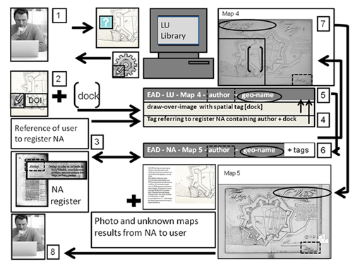
Fig 1: A future scenario of a researcher who after tagging a map in one collection receives metadata of unknown maps in another collection
In this scenario, the researcher uses the draw-over-image (DOI) tool provided by the library [box 1]. This tool allows him to indicate the object on a digital map. He sends this image with the tag “dock” to LU [box 2]. His own research documentation also contains a reference to a report in the Dutch National Archives (NA) describing the pro- and cons of the various harbor cities for which the designs were created. The researcher links this reference to the NA report to the tag of the DOI and sends it to LU [box 3]. Next, both the DOI and the tag are linked to the metadata description of map 4 in EAD that already has a link to three other files describing maps belonging to the same project [box 4]. The numbering of the maps also reveals that some maps are missing. Since the report refers to NA, the system suggests to the curator of LU a link to sources described with EAD metadata of that archive in NA. The curator accepts this suggestion and includes the DOI and tags [box 5]. By doing this, the curator of LU reconnects the information in NA with the maps in his collection [box 6]. In a query on the expected archive creator profile, in this case military, the database shows that another design from that same year for the same project exists: map 5, and even a later copy of it. The system now combines the image of LU and the metadata of all the relevant images with those of NA [box 7]. These metadata are sent to the researcher together with the photo he ordered [box 8]. Just by adding a short tag with contextual information to a photo order to LU, the PhD researcher found out that there are extra drawings in NA, which were unknown to him. LU received documentation about the context of maps in their collection. Finally, the curator of NA received metadata of the designs by the engineer Alberdingh in UL, which provides contextual information about the maps and the report on Dutch harbors to future users of these archives. However, this successful scenario simulated the annotation by only a single researcher. How can the information in annotations of many, but experienced amateur historians be used efficiently in restoring links between maps and documents without compromising the quality of the documentation of the archive?
Analyzing practices of annotators
Several studies report on the progress in tagging cultural artifacts by non-professionals in on-line collections, such as at the Powerhouse Museum in Sydney (Chan, 2007a+b) and in the well-known steve.museum research project (Trant, 2009). They are mainly based on the analysis of logs of tags and queries of the Web sites of these cultural heritage institutions. We build upon such studies by introducing in addition a more interactive, hybrid on-line/off-line method. We will combine analyses of search logs with observations of annotation practices following a so-called “thinking aloud” approach. This approach follows methods developed for analyzing the use of historical GIS interfaces (Heere 2008). We will analyze the annotating practices of two different groups of users in experiments, in a Web 2.0 environment, in the Alfalab, a research facility of the Royal Netherlands Academy of Arts and Sciences. They involve a users group of scholarly researchers of the Special Collections of Leiden University Library and a mixed users group of non-professional historians of the National Archives. The first group will apply the map annotator module in a more standardized way by structured annotations. The second group, consisting of genealogists, local historians and private collectors who work incidentally with maps during their visits to the Dutch National Archives, will be observed when they are tagging. We assume that these various observations of annotation practices will provide valuable information for a Web based multi-agent system. Herein, annotations are translated into queries. Moreover, agents are trained with this input to reconstruct increasingly lost relationships between maps and contextual documents and to offer a larger recall of objects related to the users’ queries.
Agents
Multi-agent system
A multi-agent system is one in which a number of agents cooperate and interact with each other in a complex and distributed environment. Often, the system is modeled after an organization. Agents represent one or more roles, resembling those which individual people may play. In a typical multi-agent system, each agent has incomplete information or capabilities. The agents work together to achieve a global objective based on distributed data and control. In most cases, the interaction is asynchronous and decentralized (Chau e.a., 2003). In spite of several projects using agent technology for searching and linking information resources in large repositories like digital libraries (Birukou, 2006; Chau e.a., 2003; Li, 2002; Minami, 2008; Klett e.a., 2008; Wellman, 1996), the application of agents is new to this specific domain of manuscript maps. In this case, an agent solution is attractive as well, because:
- Users vary greatly in prior knowledge about manuscript maps and archival collections. Therefore, an intelligent user agent will be helpful to guide and assist the user and eventually instruct her/him to perform better.
- As outlined above, locating sections where related documents may be available requires considerable knowledge about the administrative body that created the archival collection. Normally, this implies either a lot of study or the help of archivists. A common approach in such a situation is to make information resources more ‘intelligent’ by wrapping them in agent capabilities (Wooldridge, 2002). Expert agents can assist a user agent. They “know” the map collection and other potentially relevant archive sections.
- User agents can maintain a user profile, communicate with each other, share information and notify each other about documents of interest, thus implementing Web 2.0 principles (Birukou, 2006).
- The map collections and archive documents are distributed over several physical locations (national archives, water boards, university libraries etc.); this requires broker agents contacting expert agents on different places. The overall behavior of the system will be that a user issues a query to his user agent, which may then contact information agents directly, or may go to a broker agent, knowing which expert agent to contact (Wooldridge 2002).
A typology of agents
During the design of the system, we need to identify tasks that require the same information and combine them into one agent, to avoid excessive communication between agents. In the MATCH-Maps project, we distinguish the following types of agents:
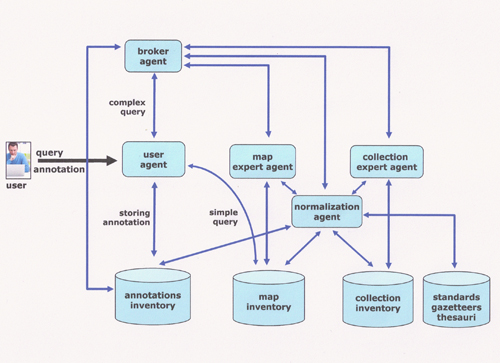
Fig 2: Conceptual scheme of agents
- The user agent comes into action when a user is accessing the system through a Web interface either by submitting a query or an annotation to the system.
The user agent is assisting the user in various ways:
- Suggesting alternatives for the query in more standardized terms and metadata extracted from the archive system.
- Handling simple questions that can be answered by lookups in the archive inventories. In this respect, the user agent acts as a user-friendly, personalized wrapper around the standard on-line search facilities.
- Maintaining and publishing the user’s profile, which includes among other things, the field of interest, a list of the queries issued, a list of the maps successfully retrieved, and the user’s annotations. The agent must be able to distill an overview, which implies some reasoning. This will enable the user agent to answer questions asked by other user agents (information sharing).
- Presenting the collected results in an integrated way on the user’s interface (see for example the concept of a Knowledge Dashboard (Chau, 2003).
- The map expert agent has thorough knowledge of map collections and the existence of thesauri with geographical information, gazetteers and ontologies. It works closely together with the collection expert agent via the broker agent. The roles of the map expert agent are:
- Checking the provenance of map annotations (authentication)
- Checking map annotations against the existing knowledge with respect to the map and its place in the collection
- Assisting in quality control of annotation and resolution of inconsistencies with existing knowledge, by interacting with the normalization agent
- Interacting with the collection expert agent(s) via a broker, to establish (possible) relations with documentation within or between cultural heritage institutions
- Helping the curator decide which relations between maps, documents and annotations hereof might be included in formal EAD/EAC descriptions.
- The roles of the collection expert agent are similar to those of the map expert agent. However, it has a wider scope and broader knowledge of the structure of other collections in the cultural heritage institution. Often, this structure reflects the organizational structure of the administrative bodies that created the documents. Therefore, the agent must understand how those bodies evolved over time, and how they relate to certain geographical places.
- The normalization agent validates the metadata relations between the collections of cultural heritage institutions and those created by the annotators. The normalization agent:
- Assists in quality control by checking annotations against normalized data sources, suggesting closely related alternatives to help resolve conflicts.
- Detects possible inconsistencies between annotations and knowledge contributed by other agents, within and across cultural heritage institutions.
- The broker agent helps to propagate information requests to other agents, both expert agents and user agents. All exchanges between agents run through the broker. It maintains a list of active user agents and expert agents, accessible along various dimensions (subject, time, place, cartographer, surveyor etc.). It is also aware of agents in other cultural heritage institutions. Furthermore, it performs all manner of bookkeeping and planning tasks, like routing queries and monitoring the progress of handling. It has the following roles:
- Mediating all the exchanges between agents with the system
- Contacting the map expert and collection agents at relevant internal and external cultural heritage institutions
- Contacting other user agents that have a similar profile with regard to the field of interest.
Annotators and Agents: An Experiment
A first experiment in a closed environment
Above we sketched a scenario in which a researcher tagged a digitized map with a draw-over-image and provided contextual information via a Web Interface, which resulted in new discoveries. Here, we discuss an experiment with agents and annotators that collaborate in gradually refining a query. During this process, they re-establish lost links between maps and contextual documents. The assumption is that agents can improve the quality of access to maps and contextual documents, by combining annotations of users with existing knowledge and the input of professional curators. This is still far away in practice. However, we have set up a first experiment in a closed environment, i.e. an environment with no real annotators, but with a fictional genealogist querying an image repository of the Dutch National Archives. The repository contains digitized maps of former colonies overseas, where one of her ancestors lived. Her query puts agents in motion “behind the screen”, that exchange information from a sample of maps and documents. Together they help refine the query, enabling the genealogist to select the map she needs. An annotation by this user leads the agent to a document directly related to the map.
Sample: VOC maps and documents
The sample comprised a small set of ca. 200 known links between maps and contextual documents from the huge archive of the “Vereenigde Oost-Indische Company” (VOC) , which spans 1243 meters, important for the rich Dutch history overseas in the 17th and 18th centuries (Zandvliet 1998). The greater part of the original documents is handwritten, not digitized, and therefore not machine-readable. However, the metadata of these sources are well documented in a 998-page inventory encoded in EAD and in several other digital repositories in various formats of VOC documents. The Dutch National Archives also maintain the Atlas of Mutual Heritage (AMH), an image repository of the VOC heritage that includes maps owned by other Dutch cultural heritage institutes.
Platform: roles of agents in experiment
The VOC experiment, in which the five above mentioned agents have specific tasks is implemented in 2APL (A Practical Agent Programming Language), a Java-based open source software platform for the development of multi-agent systems. The platform may run on several machines connected in a network, and agents hosted on different 2APL platforms can communicate with each other. The individual agents are described in terms of beliefs, goals, actions, plans, events and rules. This combination of constructs allows for agents that remember intermediate results, and use them to reason and update their own plans. The collection expert agent acts now as a VOC-expert with knowledge of the company’s history and administrative structure. The map expert explores a set of 2898 VOC manuscript maps of the collection Leupe (NA-Leupe). The normalization agent operates a gazetteer based on an index of ca. 11,000 geographical names listed in a contemporary atlas commissioned in 1691 by the VOC to Isaak de Graaf, the Atlas Amsterdam. The broker agent coordinates the exchanges between agents that are extracting geographical names, dates and information about the administrative structure of the archives from the digital repositories of maps and documents described in EAD. In addition, there is of course the user agent that in this hypothetical case translates an annotation of a researcher into a query, which brings the other agents in motion.
Experiment with a fictional annotator and real agents

Fig 3: Experiment with agents in VOC map collection
A genealogist Susan Smout, who writes a book on the history of her family, wants to know whether there are maps of Sulawesi, where one of her ancestors was a governor. The user agent sends the query to the broker agent, which forwards it to the normalization agent to check the gazetteer. The normalization agent returns its name in Dutch colonial times (Celebes) to the broker, which in turn forwards the modified query (Sulawesi or Celebes) to the map expert agent. The map expert agent returns information on 17 maps from the 17th and 18th centuries to the broker. The broker reports back to the user agent, in order to prompt the user in narrowing down the search. Susan Smout now asks “Celebes ca. 1750”, since she knows that her ancestor was active for the VOC around that time. The user agent suggests the closest documented date: 1752. The user agent returns Celebes 1752 to the collection expert agent handling the VOC documents, which in its turn reports that, due to VOC regulations of those days, a map of Celebes being shipped to Amsterdam first passed the VOC office at Makassar.
While there are many occurrences of Makassar in the VOC archives, the combination with 1752 narrows the query down to 5 maps. After examining the 5 maps more closely in the viewer, Susan Smout to her surprise recognizes on a map with the signature 4VEL1301 the name of her ancestor above a couple of tents. The text on the map also reveals that in 1741 governor Smout was on expedition to Towadjo.
We assume that Susan selects this part of the map with the draw-over-image tool (DOI) to order a high-resolution photograph of this particular detail, to illustrate her book on the Smout family. To save this draw-over-image, she types in as annotation of the selected part of the map: “detail of Smout camp on Towadjo expedition”.
The user agent sends the name “Towadjo” to the broker agent that following the above-described operations of the agents leads Susan to document 1.04.02. – 8215 folios 89-248: “Diary of the events during the expedition to and from Towadjou of 2 June 1741 received [...] from the burgher Anthonij van Dordt.”
The intrigued Susan will study the manuscript and possibly find more links to this map or to other contextual documents. The map curator is happy that a contextual document has now been linked to that particular map. Maybe in the future another genealogist, a certain Hendrik van Dordt, who has been studying the Van Dordt family for years now, will find the same map with the name of his ancestor “Anthonij” on it and link it to other contextual documents in or outside the Dutch National Archives.

Fig 4: Detail Map of Towadjo with tag
Limitations, Conclusions and Future Possibilities
The agents experiment was limited to a search within the digital repositories. We assumed input of queries and annotations by the user. Moreover, there were limitations to the agents in the experiment as well. Although most metadata in the inventories are machine-readable – in contrast to the documents themselves – the agents could not always extract the most recent information automatically, since the EAD of the maps collection is essentially based on 19th century descriptions. Some of the EAD terms need verification and, in addition, formal expression in elements and attributes agents can deal with. Such problems will certainly also occur when we extend the experiment with the less formal input of annotators. Although experiments with tagging in the context of museums showed enhancement of access to cultural heritage collections and engagement by users with specific objects (Trant, 2009), this will be time consuming at first. Furthermore, exchanges of heterogeneous information between archives, libraries and museums are complex operations. Even a simple example in a single collection, like the one in our experiment, requires many different kinds of knowledge and hints at the large number of reasoning steps humans take in searching for information. However, agents allow us to model those steps and to combine them into protocols which help to control the exchange of knowledge when the amount of information increases. Moreover, the inheritably distributed architecture of a multi-agent system matches the distributed nature of knowledge spread across multiple collections and cultural heritage institutions. The annotation tool DOI, here used to mark objects on digitized maps, is applicable in principle on any digital image in the repositories of libraries, archives and museums. In this way, annotators and agents can collaborate to obtain gradual, but increasingly quicker, access to restored links between images and contextual documents within and across cultural heritage institutions.
Acknowledgements
The authors want to thank Louisa Balk of the National Archives and Martijn Storms of Leiden University Library for providing data and information on digital repositories and metadata of their collections. Furthermore, we are indebted to Mehdi Dastani (Utrecht University – Information and Computing Sciences – Game Media and Agent Technology) for his useful suggestions for aspects of modelling of agents for the multi-agent environment described in this paper.
References
AMH - http://www.atlasofmutualheritage.nl/main.aspx?lang=en Consulted January 30, 2010.
Birukou, A., E. Blanzieri, & P. Giorgini (2006). “A multi-agent system that facilitates scientific publications search”. In Proceedings of the Fifth international Joint Conference on Autonomous Agents and Multiagent Systems. Hakodate, Japan, May 08 - 12, 2006. AAMAS '06. ACM, New York. 265-272. http://eprints.biblio.unitn.it/archive/00000888/01/TechReport_BiblicitAAMAS06.pdf Consulted January 30, 2010.
Chan, S. (2007a). OPAC2.0 - latest tag statistics and trends for simple comparison with Steve project. Published October 15, 2007 http://www.powerhousemuseum.com/dmsblog/index.php/2007/10/15/opac20-latest-tag-statistics-and-trends-for-simple-comparison-with-steve-project/ Consulted January 30, 2010.
Chan, S. (2007b). “Tagging and Searching - serendipity and museum collection databases”. Paper presented at the Museums and the Web 2007. Proceedings, Toronto, Canada. Published March 31, 2007 at http://www.archimuse.com/mw2007/papers/chan/chan.html Consulted January 30, 2010.
Chau, M., D. Zeng, H. Chen, M. Huang & D. Hendriawan (2003). “Design and evaluation of a multi-agent collaborative Web mining system”. Decision Support Systems, 35, 1 April 2003. 167-183.
EAD/CPF: http://eac.staatsbibliothek-berlin.de/index.php Consulted January 30, 2010.
Heere, E. (2008). GIS voor historisch landschapsonderzoek. Opzet en gebruik voor prekadastrale kaarten, [GIS for historical landscape research: Development and use of an historical GIS for property maps (with a summary in English)]PhD Utrecht University 27 June 2008 NGS, 375.
Heuvel, C. van den, (2009). “MAPS: Manuscript map Annotation and Presentation System - Linking formal ontologies with social tagging to (re-)construct relationships between manuscript maps and contextual documents". In Kate Singer (Ed.) Digital Humanities 2009. Conference Abstracts. University of Maryland, College Park. 22-25 June 2009. Maryland Institute for Technology in the Humanities (MITH). 138-141. http://www.mith2.umd.edu/dh09/wp-content/uploads/dh09_conferencepreceedings_final.pdf Consulted January 30, 2010.
Klett, F., A. Hägerfors, K. Aas,(eds.)(2008). Protage. State-of-the-art, Stakeholder Needs, Application Scenarios. Version 1.0. WP1 Models and Methods Research. Final status 09/09/2008: http://www.protage.eu/ Consulted January 30, 2010.
Koster, E. (2006). XML-Coding technical accuracy and historical evidence in digital historical maps. e-Perimetron, Vol. 1 no. 3-Summer 2006, 209-220. http://www.e-perimetron.org/Vol_1_3/Koster.pdf Consulted January 30, 2010.
Li, M., S. Zhou, & C. B. Jones (2002). Multi-agent Systems for Web-Based Map Information Retrieval”. In M. J. Egenhofer and D. M. Mark, (Eds.). GIScience 2002: Geographic Information Science, Second International Conference, Boulder, CO, USA. Lecture Notes in Computer Science 2478, Berlin: Springer Verlag, 161-180.
Minami, T. (2008). Library Services as Multi Agent System. In Agent and Multi-Agent Systems: Technologies and Applications. Proceedings of the Second KES International Symposium, KES-AMSTA 2008, Incheon, Korea, March 26-28, 2008. Proceedings. Lecture Notes in Computer Science 4953. Berlin: Springer Verlag, 222-231.
NA-Leupe, http://www.nationaalarchief.nl/webviews/page.webview?eadid=NL-HaNA_4.VELH.
Neatline, http://www.neatline.org/ Last updated 15 December 2009 at 12:12pm. Consulted January 30, 2010.
Trant, J. (2009.) Tagging, Folksonomy and Art Museums: Results of steve.museum research. http://conference.archimuse.com/files/trantSteveResearchReport2008.pdf Consulted January 30, 2010.
Wellman, M.P., W. P. Birmingham & E. H. Durfee,(1996). “The digital library as community of information agents”. In IEEE Expert 11(3). June 1996, 10-11. http://ai.eecs.umich.edu/people/wellman/pubs/expert96.html Consulted January 30, 2010.
Wooldridge, M. (2002). An Introduction to MultiAgent Systems. Hoboken NJ: John Wiley & Sons.
Zandvliet, K. (1998). Mapping for Money: Maps, plans and topographic paintings and their role in Dutch overseas expansion during the 16th and 17th centuries. Amsterdam: Batavian Lion International.